


Illustrating the attributes of the historic area of Kōm-al Naḍūra. These attributes resembles the urban dots of the area, scattered in the urban scene. Source: Researcher, 2021.

Illustrating the relationship between the archaeological sites to the urban archaeology, contemprary archaeology and the international charters.
Clarifying that the contemporary archaeology is the broader concept that encapsulates all the other definitions.
Source: L. McAtackney, K. Ryzewski, 2017. Visualised by: Researcher.

Defining the Urban Dots as a design concept, explaining its meaning for the interpreter in the spatial setting and how it’s being percieved. Source: O. Paans, R. Pasel, 2014. Illustrated by: Researcher.
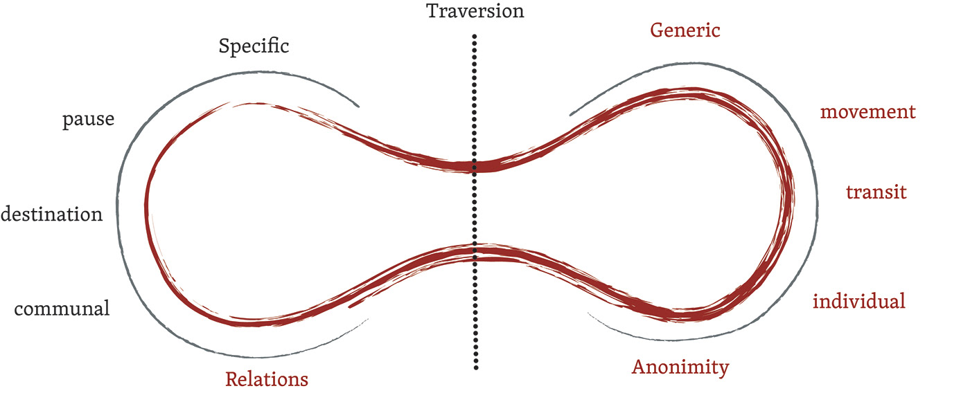
Describes the interrelation between the place and the non-place and their associated attributes; the place is specific in nature, whereas the non-place is generic. Source: O. Paans, R. Pasel.

Identifying the problem for the archaeological site of Kōm-al Naḍūra in its historic urban context. Also the map illustrates other archaeological sites in the city of Alexandria, Egypt, which are threatned by the segregation between their vitality as cultural touristic sites and the community. Source: Google Maps. Illustrated by: Researcher, 2021.

Identifying the research questions for the archaeological site of Kōm-al Naḍūra in its historic urban context; in order to create a set of objectives.

Illustrating the location of Kōm-al Naḍūra as part of al-Labban district, overlooking main historic neighbourhoods and areas of Mīnā al-Baṣl, al-Manshiyya and the western harbour. Source: Researcher, 2022.

The Intramuros of Alexandria was known for its two knolls; Kom ad-Dikka to the left and Kom al-Nadura to the right. Source: Jean Louis Bacque Grammont.
Discoursing the spatial development of the area Kōm-al Naḍūra in relation to the historic core of the city of Alexandria

Illustrating the location of Kōm-al Naḍūra in relation to the Arab city of Alexandria in the Mamluk Era. Source: Kathrin Machinek, 2014. Visualised by: Researcher, 2021.

First photo: Shows the relationship between Ibn Baṭūṭa and Gharāba cisterns to Kōm W’ala or Kōm-al Naḍūra. Second Photo: Shows Gharāba cistern interior. Third Photo: Shows Ibn Baṭūṭa cistern interior. (M12) Fourth Photo: Bāb al-Khūkha's remains. (M4) Source: K.Machinek, researcher, I.Hairy, and Y. El Gheriani. respectively.


Shows Ibn Baṭūṭa cistern in al-Kūbrī al Qadīm Street. Source: Researcher, October 2021.


Aerial views for Ibn Baṭūṭa cistern to the left, and Gharāba cisterns to the right in al-Kūbrī al Qadīm Street. Source: Researcher, March 2021.

First Photo: Abū Bakr al-Ṭarṭūshī mosque. (M13) Second Photo: Sidī al-Waqād mosque. Third Photo: Abū' ‘Alī mosque foundation stone. (M14)
Source: Bāb Maṣr, and second and third photos: Researcher, 2021.

Photos to the left: Shows the existing attributes from the Fatimid and Mamluk reigns in Kōm-al Naḍūra archaeological site nowadays. It was once the Shiekh’s burial place in the Fatimid reign, also known as Kom W’ala. Source: Researcher, 2021.
Photo to the right: The highlighted part shows the observatory tower that used to exist in the Mamluk reign on the knoll of Kōm-al Naḍūra after the collapse of the Pharos lighthouse. Source: Ugo Comminilli, 1472.

Shows the west mosque or Gāmi' al-alf 'amūd. (M15). Source: Description de l’Egypte ou Recueil des observations et des recherches qui ont été faites en Egypte pendant l’expédition de l’armée Française: VI. Antiquités, Planches, 1812.

Illustrating the location of Kōm-al Naḍūra in relation to the Arab city of Alexandria in the Ottoman Times. Source: Louis-Jacques Bourgeois, Plan de la ville et des ports d’Alexandrie, 1799. Visualised by: Researcher, 2021.

Illustrating the location of Kōm-al Naḍūra during the French Expedition, hosting Cafarelli fortress. Source: Sir Gardner Wilkinson, Planche XXXIV, Plan of Alexandria 1843, in: Jondet, M. Gaston (Ed.), Atlas Historique de la ville et des ports d’Alexandrie, 1921. Visualised by: Researcher, 2021.

Shows the original structure of Cafarelli fortress since its construction in the 18th century, during the French expedition on the knoll of Kom al-Nadūra for military defense. Source: K.Machinek, 2008.

Shows the difference between Cafarelli Fortress original structure from the 18th century and the other portions of the fortress which were newly subjected to a restoration work in 2008, Source: K.Machinek. Photographed and visualised: Researcher, 2021.

Shows the cistern of Cafarelli fortress that was added to the knoll during the French Expedition for water supply; as the knoll was used for military defense. Source: Karim Ouda. Photographed and visualized by: Researcher, 2021.

Shows Kōm al-Nāḍūra after Muḥammad’s ‘Alī development plan, overlooking and differentiating between the Turkish quarter and the European quarter in green. Source: Charles Müller, Planche XXXV, Plan d’Alexandrie Comprenant toutes ses Fortifications, Rues et Edifices Principaux 1855, in: Jondet, M. Gaston (Ed.), Atlas Historique de la ville et des ports d’Alexandrie, 1921. Visualised by: Researcher.
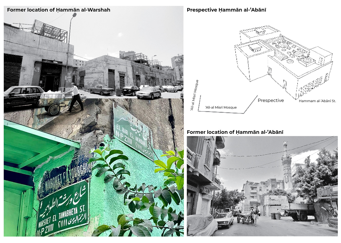
From left to right: shows the former locations of ḥammam al-Warsha and Hammam al 'Abani.
Source of the photos to the right: M. Abd al-Hafiz, M. Awad, Ḥamāmāt al-Iskandarīya fī ’l-qarnain at-tāsiʿ ʿashar wa-’l-ʿishrīn (Public Baths of Alexandria in the 19th and 20th Century), Bibliotheca Alexandria, Alexandria, 2007. Visualised by: Researcher, 2021.

Cannons on the Knoll of Kōm al-Nāḍūra that dates back from Muḥammad ‘Alī’s reign and Khedive Ismā’il. Source: Karim Ouda. Photographed and visualised by: Researcher, 2021.

Shows the newly developed area around the knoll of Kōm al-Nāḍūra in the 19th century. Source:M.A. Ḥamdī al-Falakī, Planche XXXVI, Carte D’Alexandrie 1282 De L’Hégire (1865), in: Jondet, M. Gaston (Ed.), Atlas Historique de la ville et des ports d’Alexandrie, 1921. Visualised: Researcher.

Shows the current assets on the knoll of Kōm al-Nāḍūra. Also shows the change in the structure of Cafarelli Fortress over the course of time since it’s construction till nowadays.
Drawn and illustrated by: Researcher, 2021

Shows the current assets on the knoll of Kōm al-Nāḍūra. Drawn and illustrated by: Researcher, 2021
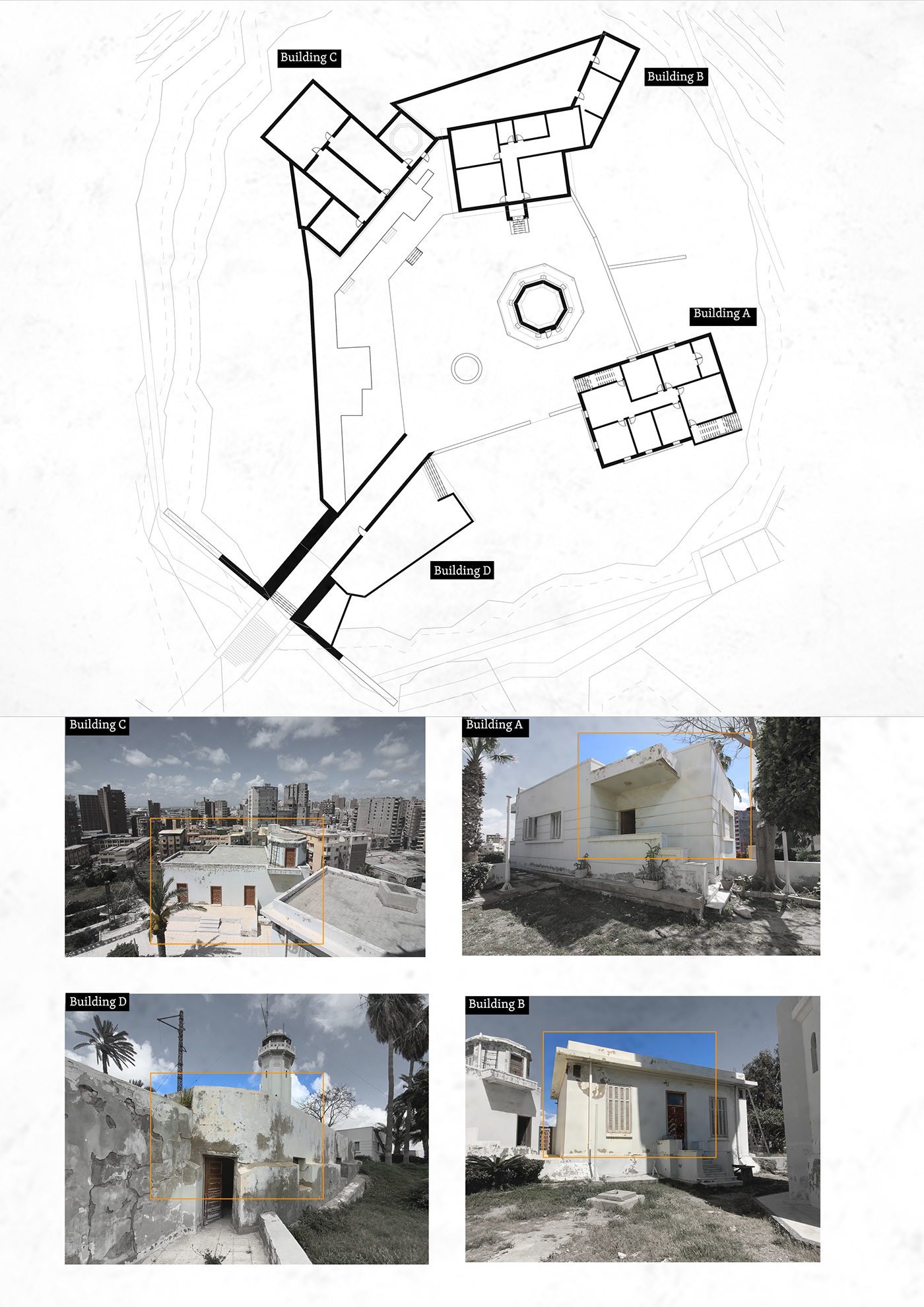
Shows the current assets on the knoll of Kōm al-Nāḍūra. Drawn and illustrated by: Researcher, 2021

Postcards in the 1920s used to showcase Kōm al-Nāḍūra knoll as Fort Napoleon, and that signifies its historic prominence to the whole city of Alexandria as a crucial landmark.
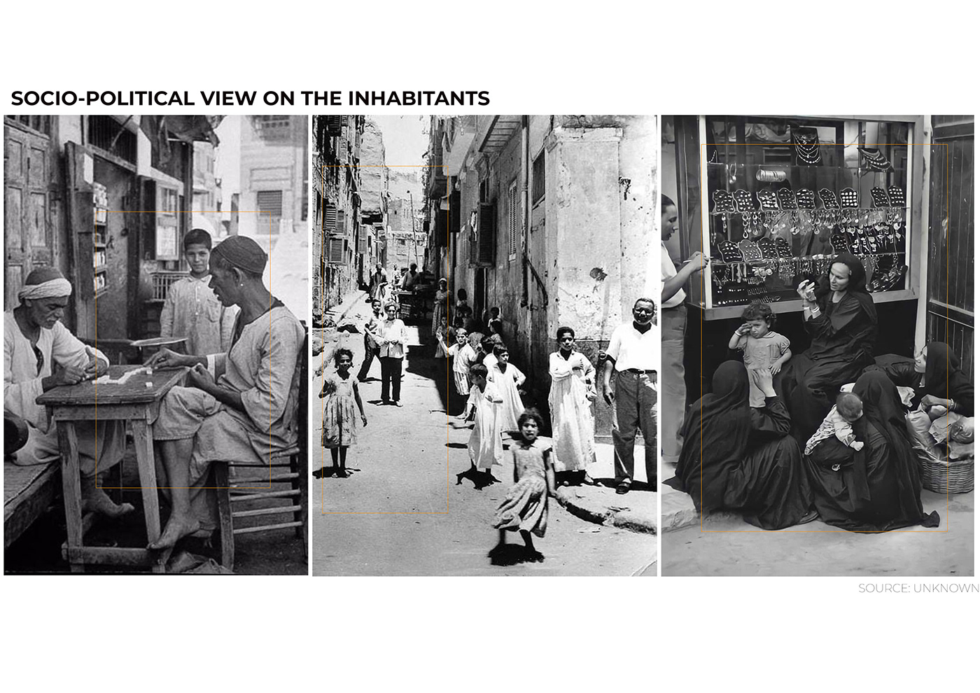
Socially, the area was inhabited by a poor social class, given the political ecologies after the first world war and the British Occupation. Unlike the European quarter inhabitants. And also the migration to Alexandria increased by 60.2 % from (1907 to 1917), and in specific to al-Labbān district where Kōm al-Nāḍūra area exists. Images source: Unknown.

Shows the urban setting of Kōm al-Nāḍūra archaeological site nowadays concerning the layers of development. Source: Google Maps, 2021. Visualised by: Researcher, 2021.

Shows postcards of the general view of Alexandria from the knoll of Kōm al-Nāḍūra in the 1920s/upper right photo: Taken by the researcher, March 2021, from the same perspective on Kōm al-Nāḍūra of the upper left postcard, with al-Ahram factory on the right as a shared asset in both the photo and postcard.
Also showing the spatial development of the area of Kōm al-Nāḍūra from a governmental to a residential district. Drawn and Visualised by: Researcher, 2021.

Showing the spatial development of the area of Kōm al-Nāḍūra from a governmental to a residential district. Drawn and Visualised by: Researcher, 2021.


Showing the intermingling between the archaeological area and the industrial activities taking place. Showing Sidi al-Waqad mosque.
Image Source: Researcher, September 2021

Postcards in the 1920s were taken from the Knoll of Kōm al-Nāḍūra, entitled general views of Alexandria, which signifies its prominence to the whole city of Alexandria, where it used to be branded as a significant landmark.

Current view from the archaeological of Kōm al-Nāḍūra, taken from the same reference points as in the post card; that illustrates the significant spatial development of the urban scene in Alexandria in terms of the built environment and the appearance of what is so-called “The Expensive Slums.” Source: Researcher, March 2021.

Shows the public transportation in Alexandria, in relation to the accessibility to Kōm al-Nāḍūra area. Source: Open street maps. Drawn and visualised by: Researcher, 2021.


Shows the change in the tram line in al-Sab’a Banāt street, hindering one of the direct access to Kom al-Nadūra area.
Source: Researcher, October 2021.

Mapping the urban dots of related interest “Cultural Heriatge Assets” from the Arab city, which are scattered in the urban sphere as invisible monuments, in the context of Kōm al-Nāḍūra area. Source: Researcher, 2021.

Defining the borders for Kōm al-Nāḍūra historic area, in order to specify the managment zone for the regeneration project, that conisists of the corze zone, buffer zone and the area of influence. This management zone is defined by overlaying and merging between the borders of al-Labban subdistrict, where Kōm al-Nāḍūra belongs, borders of the heritage area inscribed by NOUH, Egypt (National Organization of the Urban Harmony), relevant urban dots of related interest, and the western harbour.

Illustrates the defined borders for the management zone of Kōm al-Nāḍūra area, after the merging between the spatial and contextual attributes of the urban sphere. Source: Researcher, 2021.
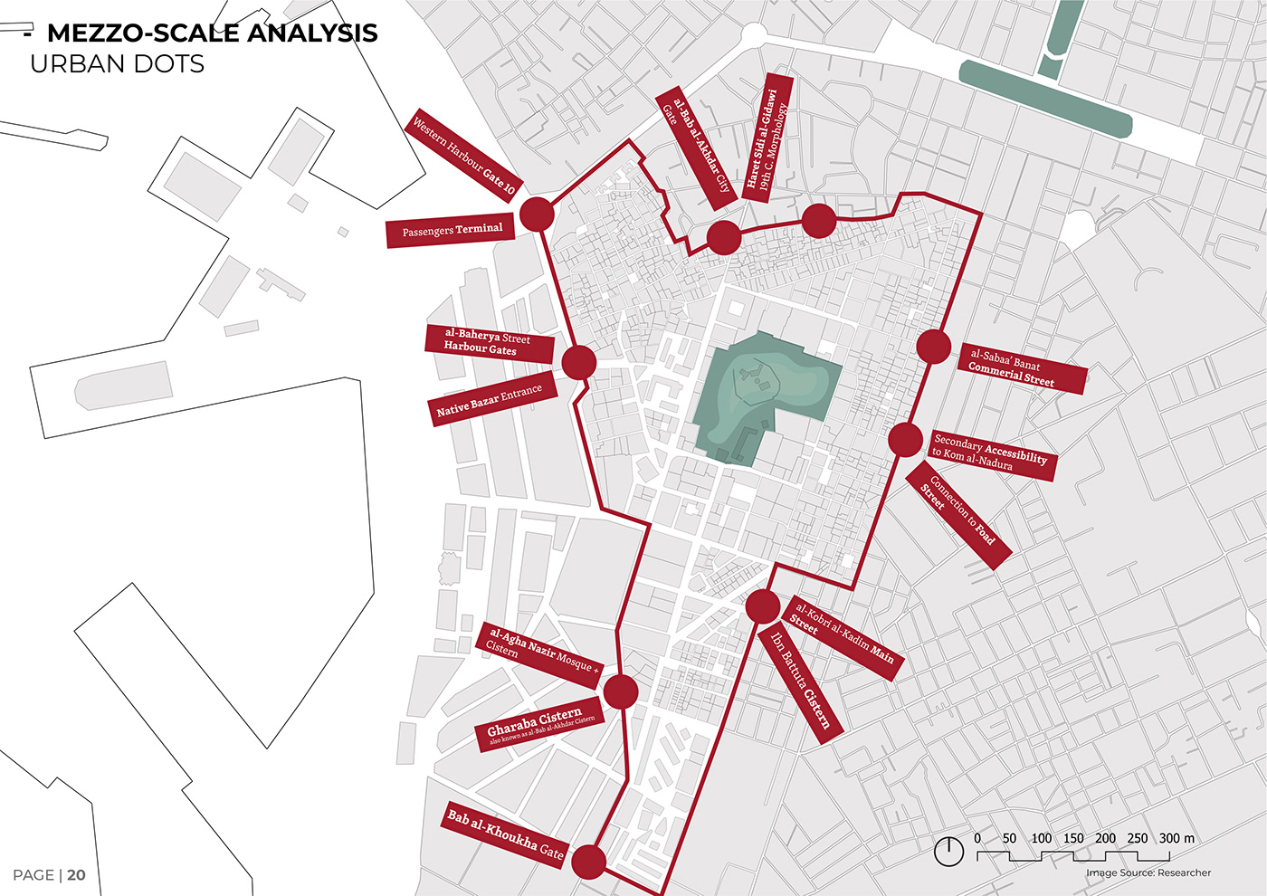
Showing the main urban dots in the managmenet zone of Kōm al-Nāḍūra historic area. Source: Researcher, 2021.

Illustrating the landuse of the management zone of Kōm al-Nāḍūra area using QGIS, in order to specify priority action plan in the regeneration stratgies. 75% are occupied by residential usage, 19% residential - commercial, and 2% are storage which are focused around the core zone of Kōm al-Nāḍūra. Source: Researcher, 2021.

Illustrating the building conditions/ state of conservation of the management zone of Kōm al-Nāḍūra historic area using QGIS, in order to specify priority action plan in the regeneration stratgies. 54% of the buildings are in a bad state of conservation. Source: Researcher, 2021.

Shows ground figure encroachments around the core zone of Kōm al-Nāḍūra. Source: Researcher, 2021.

Font typologies for the commercial activities, that used to take place in the core zone of Kōm al-Nāḍūra but nowdays they are in an abondaned state. This study is signficant for revitalising the historic character of the area, branding and new additions. Source: Researcher, 2021.


Nara Grid for checking the authenticity and integrity for Kōm al-Nāḍūra;s heritage values before the regeneration plan. Source: Researcher, 2021.

Illustrating the SWOT for Kōm al-Nāḍūra after discoursing its historical development and studying its contemporary situation. Source: Researcher, 2021.

Shows the needs assessment based on 50 semi-structured interviews with various stakeholders. Consulting the stakeholders was a crucial step in the regeneration plan, to insure their partcipation in the decision making as a bottom up approach, before and after the regenration design approach of the Urban Dots. Source: Researcher, 2021.
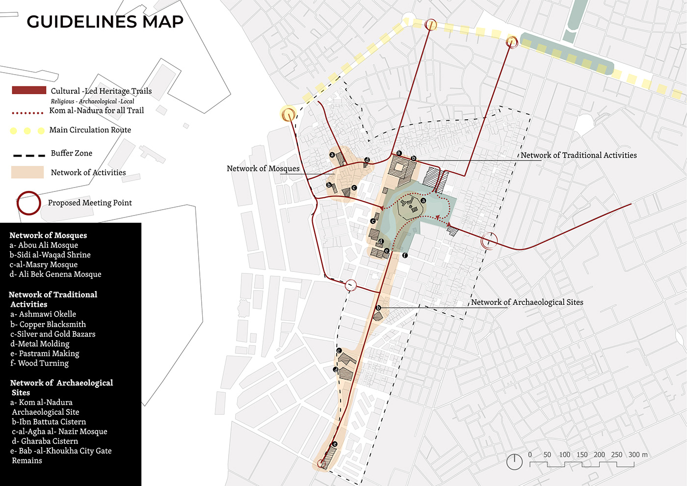
Shows the conceptual framework that applies stitching the urban dots in the contemporary context of Kōm al-Nāḍūra area. Source and Visualised by: Researcher, 2021.

Shows the master plan for stitching the urban dots in the contemporary context of Kōm al-Nāḍūra area. Source and Visualised by: Researcher, 2021.

A preliminary re-routing plan for the application of the conceptual approach of the “Urban Dots”. Towards a pedestrian priority notion for historic centres. Source: Researcher, 2021

Proposal for a cultural-led pedestrian archaeological sites heritage trial based on the “Urban Dots” conceptual framework in the historic core of Alexandria. Source: Researcher, 2021.

Proposal for a cultural-led pedestrian archaeological sites heritage trial based on the “Urban Dots” conceptual framework in the historic core of Alexandria. Source: Researcher, 2021.

Proposal for a cultural-led pedestrian archaeological sites heritage trial based on the “Urban Dots” conceptual framework for the core zone of Kōm al-Nāḍūra area. Source: Researcher, 2021.
Illustrating the proposal for a cultural-led pedestrian archaeological sites heritage trial based on the “Urban Dots” conceptual framework for the historic core of the city of Alexandria. Source: Researcher, 2021.

An overview for the regeneration strategies on the core zone of Kōm al-Nāḍūra area, as in retrofitting and adaptive reuse. Source: Researcher, 2021.


